![<?echo $_SERVER['SERVER_NAME'];?>](/template/twentyseventeen/skin/images/header.jpg)
Model NO.: G10A
Dgps: Plane: 0.25m + 1ppm; Elevation: 0.5m + 1ppm
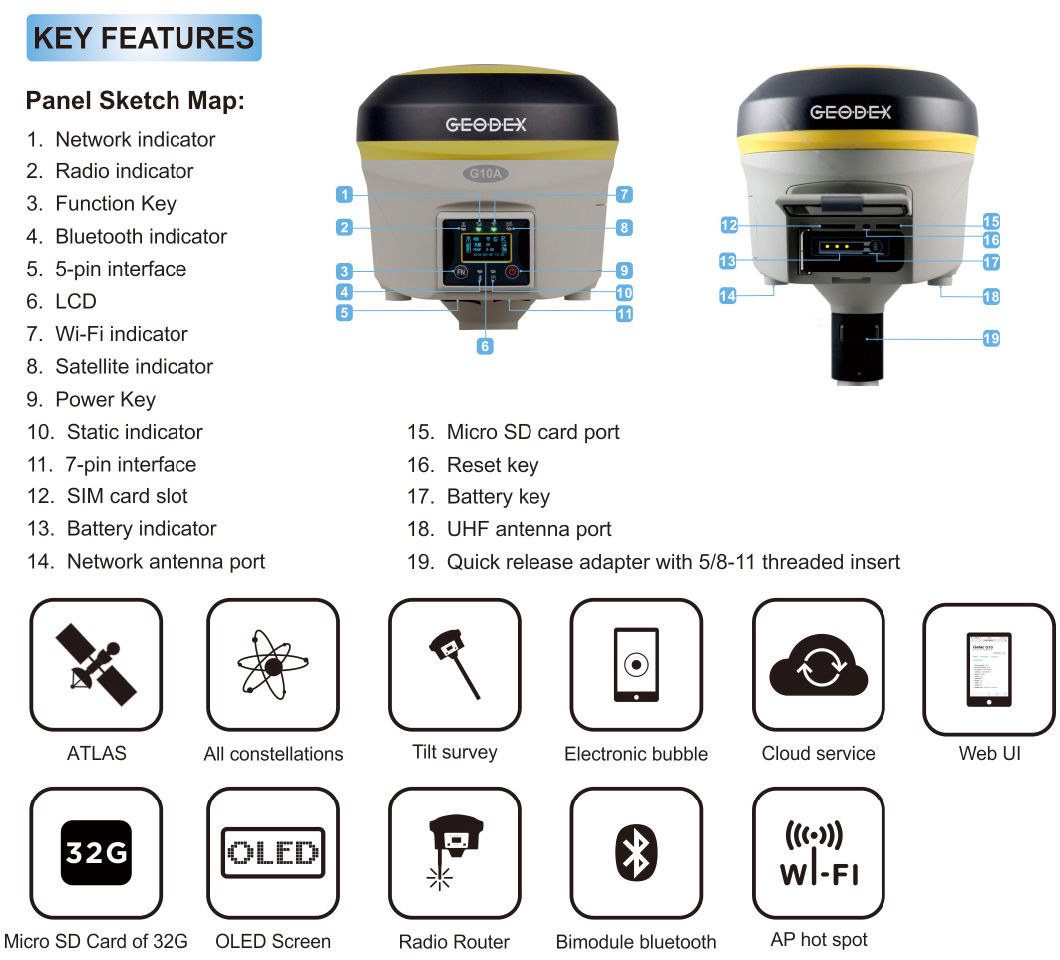
Intelligent Function: Tilt Survey, E-Bubble, Voice Guidance
OLED Screen: 1.2inch HD OLED Screen, 128*64dpi
Radio Power: Internal :2W / External :35W
Wireless Connection: Bluetooth, WiFi, Webui, Serial Port
Network Communication: WCDMA, Support HSDPA+. GPRS, GSM(CDMA EVDO)
Differential Format: Cmr. Cmr+. Rtcm23. Rtcm3. X
Trademark: GEODEX
Transport Package: Plastic Carrying Case+ Hard Carton
Specification: 50*40*20cm, 8.2KGs
Origin: Guangzhou
HS Code: 9015800090
ATLAS 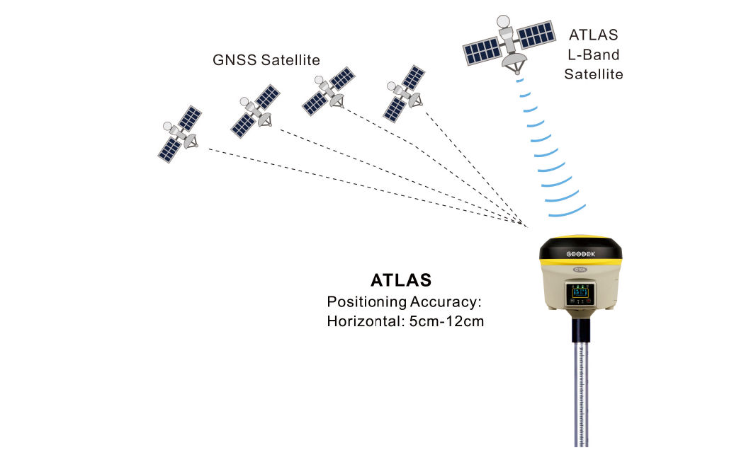
     The GNSS Receiver adopts ATLAS L-Band Satellite Based Augmentation System, Geosynchronous satellite, broadcasting data signals by L-Band to global area, which enables Single Positioning without Ground Base Stations or CORS network, can obtain a cm level accuracy; It can reach high precision easily in the Areas where is not Differential Signals, Desert, Marine, GIS data Collecting, fast single positioning.
Satellite Datalink Continuous Surveying
More continuous surveying, less downtime
     Leveraging a worldwide network of GNSS Reference stations and satellite datalinks, supporting the users obtain a cm level accuracy lasting 30-40 minutes when the satellite datalink breakdown.
Technical Specifications:
| MODEL | G10A |
| Tracking Capability | |
| Number of Channels | 372 Channels |
| Tracked Signals | GPS: L1C/A, L1C, L2C, L2EÂ Â Â Â Â Â Â Â Â Â Â GLONASS: L1C/A, L1P, L2C/A, L2PÂ BDS: B1, B2, B3 |
| Galileo: E1, E5A, E5BÂ Â Â Â SBAS: WAAS, ENGOS, GAGAN, MSAS, QZSS | |
| Positioning Accuracy | |
| ATLAS | Horizontal: 0.05m - 0.12m                  Vertical: 0.10m - 0.15m |
| Code differential GNSS positioning (DGPS) | Horizontal: ± 0.25 m + 1 ppm RMS                  Vertical: ± 0.50 m + 1 ppm RMS |
| SBAS differential positioning accuracy: Typically < 5 m | |
| Static GNSS surveying | Horizontal: ± 2.5 mm + 0.5 ppm RMS              Vertical: ± 5.0 mm + 0.5 ppm RMS |
| Real Time Kinematic surveying (RTK) | Single Baseline < 30km: Horizontal: ± 8 mm + 1 ppm RMS       Vertical: ± 15 mm + 1 ppm RMS |
| Network RTK: Horizontal: ± 8 mm + 0.5 ppm RMS           Vertical: ± 5 mm + 0.5 ppm RMS | |
| Initialization time: Typically < 8 seconds     Initialization reliability: Typically > 99.9% | |
| Tilt survey (2m GPS pole): 10 degree to 30 degree: 10mm to 30mm | |
| Hardware Physical | |
| Size (W × H) | 14.1cm × 14cm |
| Weight | 1.45kg with battery |
| Material | Magnesium alloy shell |
| Temperature | Operating Temperature: -30ºC ~ +65ºC      Storage Temperature: -40ºC ~ +75ºC |
| Humidity | 100%, condensing |
| Dust/Water Protection | IP67 at closing all connector caps. Protected against temporary immersion up to 1m depth. |
| Shock and vibration | Designed to survive a 2m natural fall onto concrete |
| Electrical | |
| Power | 9 to 22V DC external power input with over-voltage protection |
| Rechargeable | Removable 11.1V, 3.4Ah Lithium-ion smart battery with LED status indicators |
| Input voltage | 100 to 240V AC (50/60Hz) |
| Power consumption | 6.2W in RTK rover mode with internal radio |
| Operating times on single battery | Static mode: 12 hours                   UHF receive only option: 8 hours |
| UHF receive/transmit option (2.0W): 4.3 hours | |
| WCDMA/GPRS receive option: 6 hours | |
| Operation system | |
| Button | Double buttons and visual operation interface |
| LCD | 1.2inch HD OLED screen, 128 × 64 dpi sunlight readable |
| Voice | iVoice intelligent voice technology provides status and operation voice promptly |
| Communications and Data Storage | |
| Internal Radio | Frequency: 410 ~ 470MHz                         Working range: 3 ~ 5km |
| Transmitting power: 0.5W/2W adjustable | |
| External Radio | Frequency: 410 ~ 470MHz                         Working range: 8 ~ 30km |
| Transmitting power: 5W/35W adjustable | |
| Cellular | WCDMA3.5G, GPRS/EDGE (option CDMA2000/EVDO 3G) |
| Bluetooth | Bluetooth2.1 + EDR/Bluetooth 4.0 BLE |
| Wi-Fi | 802.11 b/g/n, access point mode |
| Data storage | Internal Memory: 4GBÂ Â Â Â Â Â Â Â Â Â Â Â Â Â External Memory: Micro SD card (Max.32GB) |
| Data Formats | 1Hz positioning output, up to 20Hz |
| CMR, CMR+, RTCM2.3, RTCM3.0, RTCM3.1, RTCM3.2 | |
| MSM input and output | |
| Web UI | Offers simple configuration, operation, status, and data transfer |
| Accessible via Wi-Fi, Serial, USB, and Bluetooth | |
| I/O port | |
| GPRS antenna connector/UHF antenna connector DC power input (5-pin)/RS232 and USB port (7-pin) SIM card slot/1 X Micro SD slot | |
| Tilt Survey System | |
| Built in tilt compensator, correcting coordinates automatically according to the tilt direction and angle of the centering rod | |
| Electronic Bubble | |
| Controller software display electronic bubble, checking leveling status of the centering rod real time | |
| Data cloud service | |
| Web page cloud service management platform, supporting online register etc. | |
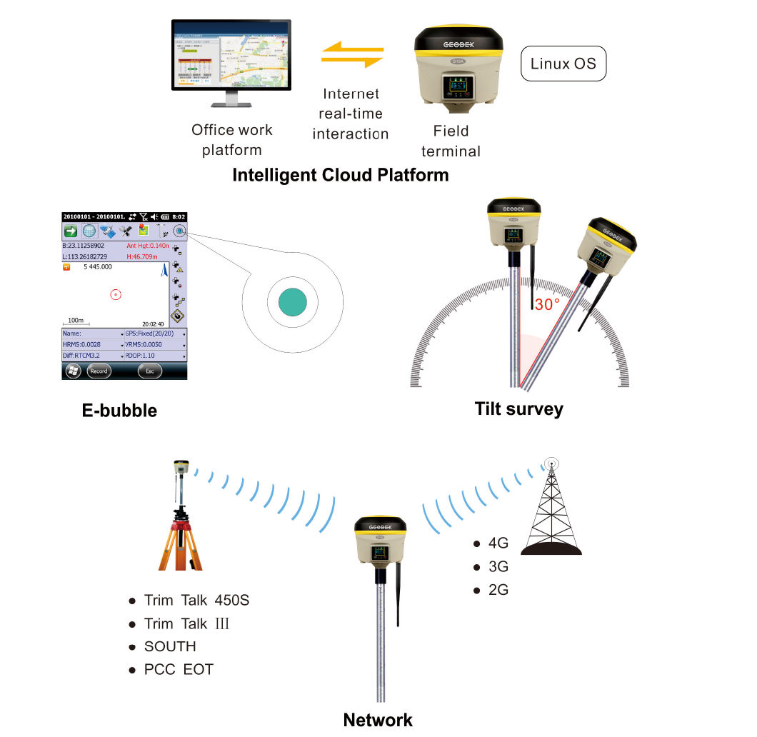
Intelligent Cloud Platform
4 In 1 Food Processor
4 In 1 Food Processor,Multifunctional Food Processor,Cooks Multi Function Food Processor,4 In 1 Multi Functional Food Mixer
Jiangmen Sanxin Appliances Co.,Ltd , https://www.sanxinfty.com